[해외 DS] 드론-AI, 우크라이나에서 지뢰 탐지 지원
지뢰 제거는 위험하고 시간이 많이 소요되는 작업
드론-AI 기술로 지뢰 제거 속도와 효율성 크게 향상해
정확도 개선 및 지표면 아래 지뢰 탐지 기능 추가 필요
[해외DS]는 해외 유수의 데이터 사이언스 전문지들에서 전하는 업계 전문가들의 의견을 담았습니다. 저희 데이터 사이언스 경영 연구소 (GIAI R&D Korea)에서 영어 원문 공개 조건으로 콘텐츠 제휴가 진행 중입니다.
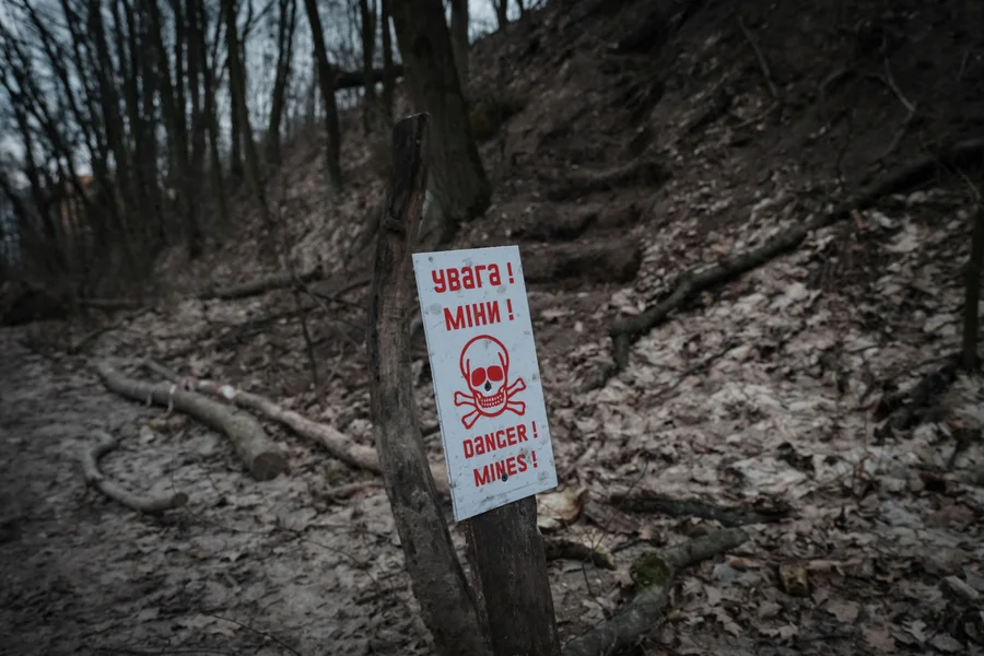
지뢰 제거는 시간이 많이 소요되는 작업으로 알려져 있다. 그리고 기술의 혁신이 오랜 기간 부재했었다. 2차 세계대전 이후 사용됐던 기술 수준을 벗어나지 못했고 작업 과정도 노동집약적이다. 그러나 컬럼비아대학교의 화산학및원격탐사학 박사과정생 재스퍼 바우어(Jasper Baur)와 Safe Pro Group(개인 보호 장비 제조업체)은 드론과 AI 기술을 융합하여 지뢰 제거 과정을 혁신하고자 한다. 드론과 AI의 결합은 지뢰를 빠르고 효율적으로 탐지하며 안전하게 제거하는 데 도움을 줄 것으로 기대된다.
탐지 정확도는 떨어지지만, 넓은 지역 효율적으로 분석할 수 있어
아이디어는 놀라울 정도로 간단하다. 먼저 드론이 지뢰가 매설된 것으로 추정되는 지역 상공을 비행하며 대량의 이미지를 수집한다. 그다음 70가지 유형의 지뢰, 집속탄, 기타 불발탄의 시각적 특성에 대해 학습된 바우어의 알고리즘은 이미지를 0.5인치 이하의 해상도로 처리하여 지도를 만든다. 그러면 이 모델은 사람이 같은 이미지를 검토하는 것보다 더 빠르고 정확하게 폭발물을 인식하고 매핑할 수 있다. “몇 분 안에 모든 지뢰 탐지 위치를 지도에 표시할 수 있다”라고 바우어는 강조했다.
약 90%의 탐지율을 보이는 드론은 기존 방법을 대체하는 것이 아니라 보강하는 역할을 한다. 지뢰를 하나하나 살펴보는 것이 아니기 때문에 정확성은 떨어지지만, 수작업에 비해 더 많은 지역을 커버할 수 있는 장점이 있다. 바우어와 그의 팀은 우크라이나에서 전쟁이 시작된 이래로 이 기술을 테스트하기 위해 우크라이나를 여러 차례 방문했다. 일부 추정에 따르면 우크라이나에는 지뢰와 기타 폭발물을 숨길 수 있는 약 67,000제곱마일(플로리다주와 비슷한 면적, 대한민국 국토의 약 1.7배)의 땅이 있다. 드론 AI 시스템을 사용하면 지뢰 제거 팀을 투입하기 전에 넓은 지역을 스캔하여 오염 밀도가 가장 높은 곳부터 제거 작업을 시작할 수 있어서 효율성이 극대화될 전망이다.
전쟁 피해 크지만, 지속적인 기술 혁신으로 복구 전망은 긍정적
싱크탱크 GLOBSEC이 발표한 추정에 따르면 우크라이나가 기존의 방법과 현재의 자원으로 피해를 복구하는 데는 750년 이상 걸릴 것이며, 우크라이나 경제부가 공유한 수치에 따르면 11월 1일 현재 러시아의 침공 이후 최소 264명의 민간인이 지뢰로 사망하고 830명 이상이 다쳤다. 세계은행은 제거 비용이 370억 달러를 넘을 것으로 추정했다. 그러나 지뢰 제거 관계자와 국제 전문가들은 우크라이나에서 개척되고 있는 지뢰 제거 혁신으로 인해 제거의 속도, 효율성 및 안정성을 영원히 바꿀 것으로 전망했다.
현재로서는 표면에 있는 폭발물만 감지할 수 있으며, 깊이 묻혀 있거나 초목으로 덮여 있는 폭발물은 감지할 수 없다. 이에 바우어가 설립한 비영리 단체인 지뢰제거연구커뮤니티(Demining Research Community)는 열화상 및 지표 투과 레이더를 사용하여 더 깊은 곳까지 살펴볼 방법을 테스트하고 있다. 또한 초목의 양에 따라 지뢰 탐지 결과에 대한 AI의 신뢰도를 평가할 수 있는 모델도 함께 개발 중이다.
한편 바우어 외에도 개인과 기관이 각자의 위치에서 힘을 모으고 있다. 우크라이나 정부는 미국의 데이터 분석 기업인 Palantir와 협력하여 이전에 사일로화되어 있던 수십 개의 데이터 스트림을 결합하고 어떤 지뢰 제거가 가장 큰 영향을 미칠지 결정하는 모델을 개발했다. 또한 지뢰 신고 앱을 개발한 우크라이나 대학생 프로그래머와 트랙터를 지뢰 제거 기계로 개조한 농부들도 지뢰 제거 작업에 힘을 보태고 있다. 전쟁의 피해가 지금도 발생하고 있는 우크라이나에서 지친 몸과 마음을 달래는 한 줄기 빛과 같은 소식이다.
Drones and AI Could Locate Land Mines in Ukraine
An AI model could speed up laborious and dangerous demining efforts
Finding and removing land mines is an excruciatingly slow process. Human deminers scour contaminated ground inch by inch with handheld metal detectors, waiting for the telltale beep of a magnetic anomaly. Although trained dogs are sometimes used, metal detectors have remained the go-to clearance method since the end of World War II.
“There’s a very long period where there hasn’t been much innovation in the field,” says Jasper Baur, a Ph.D. student in volcanology and remote sensing at Columbia University. Baur and his collaborators at Safe Pro Group, a manufacturer of personal protective gear, have been developing a drone-based machine-learning technology to make demining safer and faster than with traditional methods.
The idea is deceptively simple: A drone flies over an area thought to be mined, collecting a large volume of images. Baur’s algorithm, trained on the visual characteristics of 70 types of land mines, cluster munitions, and other unexploded ordnance, processes the images into a map, with resolution down to a fraction of an inch. The model can then recognize and map explosives more quickly and accurately than a human reviewing the same images. “In a matter of minutes you’ll have a map plotted out with where all the land-mine detections are,” Baur says.
With a reported detection rate of about 90 percent, the drones are meant to augment traditional methods, not replace them. “It’s less comprehensive because you’re not going through inch by inch,” Baur says. But the approach can reveal potential dangers and can cover more ground than manual efforts.
Baur and his team have visited Ukraine to test the technology multiple times since the start of the war there. They hope their work can speed up a demining process that, using current resources, could take more than 750 years. By some estimates, Ukraine has about 67,000 square miles (an area roughly the size of Florida) that could harbor mines and other explosives. With the new system, “you can scan wide areas of land and try to figure out where the highest density of contamination is” before sending in humans to defuse the mines, Baur says.
For now the AI can detect only surface-level explosives, not deeply buried ones or those covered by vegetation. Baur’s nonprofit organization, the Demining Research Community, is testing ways to look deeper by using thermal imaging and ground-penetrating radar. It is also developing a model that can rate the AI’s level of confidence in its mine-detection results based on the amount of vegetation present.
Milan Bajić, an expert in remote sensing who has been involved in demining efforts in Croatia, says the approach is a valuable addition to the demining tool kit. “There is no silver bullet of technology,” he says, “but combining different technologies can be more successful than any of them.”
![[해외 DS] 고대 헤르쿨레니움 두루마리를 해독한 AI 경진대회 ③, 베수비오 챌린지의 게임체인저는 다름 아닌 인간 집단지성](https://kr.giai.org/wp-content/uploads/sites/3/2024/03/AI_Competition_Decoded_An_Ancient_Scroll_4_ScientificAmerican_20240322-768x512.webp)
![[해외 DS] 잊혀진 사용자 편의성, AI로 위기 모면할 수 있을까](https://kr.giai.org/wp-content/uploads/sites/3/band-aid.png.webp)
![[해외 DS] AI는 실질적인 해를 끼친다](https://kr.giai.org/wp-content/uploads/sites/3/harm.png.webp)
![[해외 DS] 마침내 인공지능으로 동물과 대화할 수 있다](https://kr.giai.org/wp-content/uploads/sites/3/whale.png.webp)
![[해외 DS] AI 학습 데이터, 스마트한 IP 법이 필요하다 (2)](https://kr.giai.org/wp-content/uploads/sites/3/jurisdiction.jpg.webp)
![[해외DS] 세일즈포스, ‘긴 문서 특화’ LLM 출시···벤치마크 ‘깡패’](https://kr.giai.org/wp-content/uploads/sites/3/2.jpg.webp)